Custom Search
Showing posts with label Serras. Show all posts

Tuesday, July 9, 2019

Visit the Serra da Gardunha - Louriçal do Campo

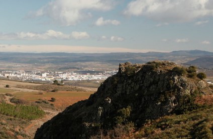
The Serra da Gardunha is a mountain range of Continental Portugal, 20 km long, 10 km wide and 1227 meters high. It is located in the municipalities of Fundão and Castelo Branco, and in the latter it includes an area of the Parish of Louriçal do Campo.

Sunday, April 7, 2019

Visit the Castle of Bragança - Santa Maria (Bragança)

The Castle of Bragança located in the parish of Santa Maria, in the historical center of the city of Bragança, is one of the most important and well preserved Portuguese castles. From the top of its walls you can see the mountain ranges of Montesinho and Sanabria (to the north), Rebordões (to the northeast) and Nogueira (to the west).
D. Sancho I (1185-1211) endowed the town with the first walled fence in 1188.
Under the reign of D. Dinis (1279-1325), it was determined to erect a second walled perimeter in 1293.
Already under the reign of D. Fernando (1367-1383), he received works of improvement. At this stage, when this sovereign was involved in the succession dispute of Castile, Bragança was surrounded and conquered by the Castilian troops, returning to the Portuguese possession only by means of the signing of the Treaty of Alcoutim (1371). The keep was built around 1439.
The castle is of oval plan and set in the quota of 700 meters above sea level, it is constituted by a fence ameada with a perimeter of 660 meters, reinforced by fifteen cubes. The walls, with an average thickness of two meters, cover the historic center of the city, occupying an area of ​​about three hectares, and delimited four spaces, guided by two road axes, whose main is the old street of the Citadel. In its interior the visitor can appreciate the buildings of the Domus Municipalis (unique example in the country of the Romanesque civil architecture and that is believed to have had, originally, the functions of tanker). In this fence, three doors are torn (two under the invocation of St. Anthony and the Door of the Sun, to the East) and two shutters (the Door of Betrayal and the Postigo of the King's Well).
The main door of Santo António, in a perfect back arc, between two turrets, is defended by a barbican, in which is located the Door of the Village, in ogival arc. In the interior, in the square of arms, it is possible to observe the adaptations of the accesses and the platforms destined to the artillery.
In the North sector, where the installations of Battalion of Hunters # 3 were erected, stands the Tower of Menagem, of square plan, with 17 meters of width, rising to 34 meters of height, attached to the fence. In shale masonry, abundant rock in the region, in the wedges and openings granite was used. Its interior, where the dungeon and the cistern are, is divided in two floors, with rooms covered by vaults of edge, reinforced by arches torais. At first a drawbridge reached the door in a higher plane, now replaced by an external staircase, masonry attached to the north face of its armor. In the South face, half height of the tower, is a stone of arms with the coat of arms of the House of Avis. The top is crowned by cross-sectional battlements, countertops with kills, with four cylindrical guards at the vertices, dominating, on the East face and the South face, two mainelated Gothic windows. A fence, reinforced by seven cubes (three to the east, three to the west and one to the south) of circular plan, defend the exterior of the tower, delimiting an approximately rectangular space.
Also on the north side of the outer fence, next to one of the basins, stands the so-called Torre da Princesa, former Paço do Alcaide. Building of residential characteristics (torre-alcáçova), its existence is surrounded by stories, one of the most popular the legend of the Moorish princess. In historical times, it is said that it was inhabited by D. Sancha, sister of D. Afonso Henriques, as a refuge in the face of marital infidelities practiced by her husband Fernão Mendes. In her, was also imprisoned D. Leonor, wife of the fourth Duke of Braganza, D. Jaime, accused (unjustly) of adultery by the own husband. The duke ended up murdering his wife, in the Paço Ducal of Vila Viçosa, stabbing, on November 2, 1512.
In the south sector, a projection of quadrangular plant is closed by Poço del'Rei, structure XVIII with the function of defense of a cistern.

Tuesday, March 19, 2019

Visit the Castle of Tourão - Rebordãos

The Castle of Tourão, located in the Parish of Rebordãos, is located in a small spire in spur, in the hillside and in the northeast limit of the mountain range of the Nogueira. The first occupation of the place will have been a small fortified settlement, of the Final Bronze or Iron Age, of which there are scarce vestiges.
The second phase of occupation corresponds to the construction of a small medieval rock castle, whose occupation extends to the modern era. From this rocky castle there are still evident traces of structures, which, though heavily overturned, are still preserved in the foundations and some walls of considerable dimensions.

Friday, January 25, 2019

Visit the Sabor River - Grijó de Parada

The river Sabor is a river that is born in Spain crosses the Mountain range of Montesinho and several parishes of Bragança, among them Grijó de Parada

Friday, July 27, 2018

Visit the mountain bike course of the Municipality of Bragança

The mountain bike route of the Municipality of Bragança begins in the city of Bragança, in the historical center, next to the Castle. From where you can see the Serra de Montesinho, where it follows the percuros. The entrance to the Natural Park is soon in Gimonde at 6km.
In Quintanilha is the Apples River, bordered by Spain. This is an area full of old water mills and water mills. Continuing along the route to the north, one arrives at the village of Rio de Onor, one of the last transmontanese community villages. In this border village, goods are still shared within the community, such as the community oven, cattle or even land. The crossing of the River Onor is through a Roman Bridge, after which it continues south towards the villages of Varge and Aveleda. Again next to the border, we can see what remains of the Mineiro de Portelo Complex, now inactive. A few kilometers later you come to the village of Montesinho.
Subsequently, it goes to the Serra Serrada dam, one of the highest points of the course, circling the 1300 meter altitude.
Further south, in the village of Portela you can visit the Interpretive Center of Nature and get to know the fauna and flora of the region better. In the next 28 km you descend almost 1000 meters of unevenness, but in the next 26 km you will climb them again, arriving at the Sanctuary of Mrs. da Serra in the middle of Serra da Nogueira. This will probably be the most demanding part of the route, but the view is well worth it.
You reach Izeda, the southernmost point of the route. On leaving this village you will pass a remarkable olive grove, in the direction of Coelhoso, where you can contemplate another Mining Complex: Minas de Ribeira, with particular interest in the bridge that was used by the miners to reach Outeiro. After passing through Grijó de Parada, Freixedelo and Alfaião, one arrives again at Bragança, with about 255 km elapsed.

Thursday, June 3, 2010

Visit the Cova da Beira - Fundão

The Cova da Beira is a sub-region and a plateau forming part of the District of Castelo Branco. Has its limits: the north by the Serra da Estrela and the Beira Interior Norte, east to the Beira Interior Sul, south to Beira Interior Sul Pinhal Interior and the south and west to the Pinhal Interior Norte. It has an area of 1373 square kilometers and a population, according to the 2001 census of 93 580. Besides the Municipality of Fundão the pit border covers the counties of Covilhã and Belmonte.